Atlas User Manual
Table of Contents
A. Background
B. Map Controls & Navigation
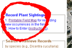
C. Contributing New Plant Occurrence Records
D. Search for Plant Occurrence Records
E. Printing Herbarium Labels from WikiPlantAtlas
This atlas utilizes the Google Maps API backed by a mySQL database run on a Linux server at GoDaddy.com. PHP and Javascript are the programming languages used to make it all work. Data contributed to this site are available to the world on the World Wide Web immediately after entering and are backed up securely on a daily basis at GoDaddy.com.
1. Switch between "map" (including "terrain") and "satellite" map views with buttons in the upper left of the map window. Hybrid is recommend and is the default type.
2. Zoom using either the "+" and "-" buttons in the lower right of the map window, OR quickly zoom with the roller wheel of your mouse.
3. Pan (move map from side to side) with left mouse click and drag, OR with the arrow buttons in the upper left of the map window.
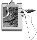
Unless you have your computer and internet access with you at the time of a plant sighting / collection, you will need some way of recording your location for later entry into the Atlas once you have access to a computer. And "no", there is no smartphone app currently available to make your contributions immediate from the field.
This Atlas is a place to not only share and manage your own plant occurrence records, but it is also a place to learn where others have seen or collected plants in the past. The far majority (240,000) of the records in the WikiPlantAtlas database are from the Pennsylvania Flora Project. Several thousand more are from contributors such as yourself. You can search for these records using the left search pane from the main "Sightings" page.
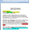
The record pop-up info window associated with each sightings marker is formatted like most labels. Therefore, if a voucher specimen(s) was collected with a sighting, one can prepare labels for the voucher specimen as follows.
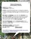
Click on a sightings marker to open the pop-up info window.
| 
|
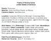
Select and copy the required fields. "Digital Record Contributor" and "Date contributed"
contain information about who and when the record was entered into NatureAtlas; as such, they have nothing to do
with making voucher specimens and so don’t copy them.
| 
|
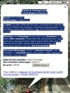
Paste into the Word document labels.doc, which is specially formatted with two columns.
| 
|
Repeat for other records for which you wish to make voucher specimen labels, appending by pasting in to the existing file.
| 
|
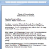
Proofread the label information in Word and delete unnecessary punctuation (shown in teal, such as double ";"s, double "."s, unused "DBH:" or "Abundance:" fields).
If not automatically done, italicize species binomial and, when present, subspecific epithets (shown in green). Do not italicize authors or subspecific taxon specifiers such as "ssp." or "var."
If any required info is missing, then return to record pop-up window, click the edit button and add this information to the record and refresh the query for that record to obtain the updated info window before attempting to make a label.
| 
|
Select all text, and format as desired (e.g., 10 pt font is recommended).
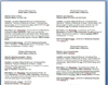
Your final label will look like this.
| 
|
Print onto acid-free, archival paper.
| 
|
Cut out individual labels for each herbarium specimen.
| 
|